

Type: Municipality
Island Group: Visayas
Region: Western Visayas
(Region VI)
Province: Negros Occidental
Barangay Count: 9
Coastal/Landlocked: Coastal
Marine Water Bodies: Tañon Strait
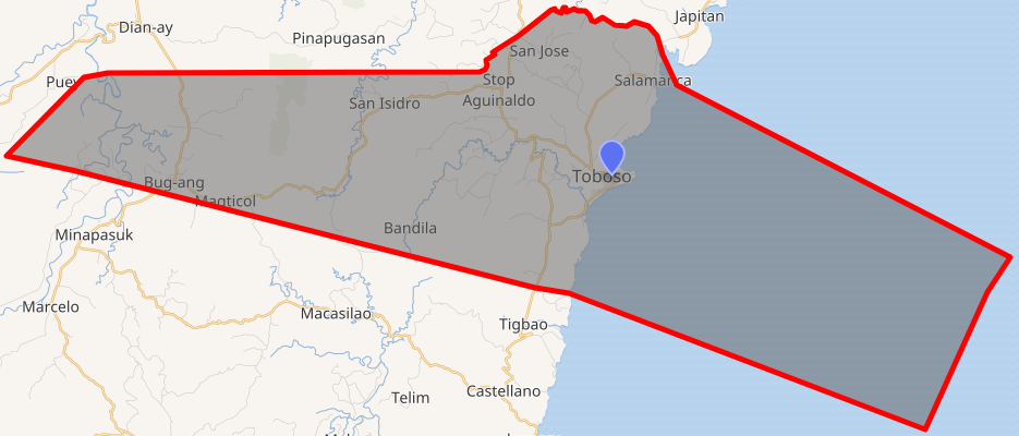
Geographical Location: The municipality of Toboso is located on the northeastern side of the province of Negros Occidental and is facing the island of Cebu. It is bounded on the southwest by the municipality of Calatrava; Northwest by the city of Sagay; north by the municipality of Escalante and east by Tañon Strait. The shoreline runs along the Tañon Strait from Calatrava boundary to the Escalante boundary facing east.
Coordinates: 10º40’00” N to 10º42’56” latitude and 123º20’00” E to 123º30’51” longitude.
Land Area: DBM: 11,733 has.
DENR 2013: 12,134.18 has.
Historical Data: 12,340 has.
| Cookie | Duration | Description |
|---|---|---|
| cookielawinfo-checbox-analytics | 11 months | This cookie is set by GDPR Cookie Consent plugin. The cookie is used to store the user consent for the cookies in the category "Analytics". |
| cookielawinfo-checbox-functional | 11 months | The cookie is set by GDPR cookie consent to record the user consent for the cookies in the category "Functional". |
| cookielawinfo-checbox-others | 11 months | This cookie is set by GDPR Cookie Consent plugin. The cookie is used to store the user consent for the cookies in the category "Other. |
| cookielawinfo-checkbox-necessary | 11 months | This cookie is set by GDPR Cookie Consent plugin. The cookies is used to store the user consent for the cookies in the category "Necessary". |
| cookielawinfo-checkbox-performance | 11 months | This cookie is set by GDPR Cookie Consent plugin. The cookie is used to store the user consent for the cookies in the category "Performance". |
| viewed_cookie_policy | 11 months | The cookie is set by the GDPR Cookie Consent plugin and is used to store whether or not user has consented to the use of cookies. It does not store any personal data. |