Municipality of toboso Brief historical background

Before Spanish Regime

The origin of Toboso dated back many years before the Spanish regime. The original settlement was near Sagahan River and the community was popularly known as “Sag-ahan” which means in the local dialect “to take out or catch fish by the hands” because fish abound in the area.

The Naming of Toboso

When the Spaniards came, the community was named TOBOSO in honor of a similar community in Spain, La Villa del Toboso. During the Spanish regime, Toboso was a barrio of Escalante. The community had expanded with the coming of immigrants from the island of Cebu and developed extensively in fishing, agriculture and commerce.
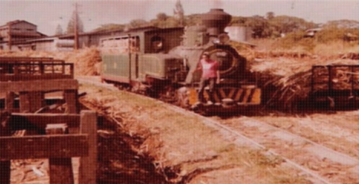
American Rule

In the early days of the American rule, more impetus was dedicated to a sugar central called the Central Azucarera del Danao at Labilabi, 6 kilometers from Toboso. The development of the sugar industry was started.

The Separation from Escalante

Toboso separated from Escalante and was declared a new town effective July 1, 1948 by virtue of Executive Order No. 141, series of 1948, issued by President Elpedio Quirino.

Vibrant and Alive History

Toboso’s history is vibrant and alive despite of the many turbulent setbacks and consequences of the past and modern times. Its people are known for being resilient, hospitable, patient, peace-loving, steadfast and determined to achieve under varying circumstances and of their loyalty, cooperation and economy. With these, it is not impossible to expect only the best for the future of Toboso.

toboso

Negros Occidental

our officials

Meet our civil servants
HON. MADONNAH M. JAOJOCO Municipal Mayor

Mission

Gateway of trade and commerce and premier provider of agri-industrial products in Negros Island with empowered, peaceful, healthy and resilient community pursuing growth with equity, living in adaptive and balanced environment; and participating in the democratic process of governance

vision

To spearhead the development of industrial potentials to become the gateway of trade and commerce in Negros Island, intensify agricultural production, enhance program on human resources to include manpower development geared towards the labor requirements of industries and agri-business sectors to improve the living condition of the people in an adaptive and balanced environment through the concerted efforts of all stakeholders in the community guided by the fundamentals of good governance.

summary data

Type: Municipality

Island Group: Visayas

Region: Western Visayas

              (Region VI)

Province: Negros Occidental

Barangay Count: 9

Coastal/Landlocked: Coastal

Marine Water Bodies: Tañon Strait

Geographical Location: The municipality of Toboso is located on the northeastern side of the province of Negros Occidental and is facing the island of Cebu.  It is bounded on the southwest by the municipality of Calatrava; Northwest by the city of Sagay; north by the municipality of Escalante and east by Tañon Strait.  The shoreline runs along the Tañon Strait from Calatrava boundary to the Escalante boundary facing east.

Coordinates: 10º40’00” N to 10º42’56” latitude and 123º20’00” E  to 123º30’51” longitude.

Land Area:  DBM: 11,733 has.

DENR 2013: 12,134.18 has.

Historical Data: 12,340 has.